

Someone smart is going to have to answer but it is the lack of rain that defines a desert rather than the temperature. I imagine this is determined by closeness to water, currents, and a million other things. Temperature I am sure is a factor, but far from the only one.
Now hopefully someone smart who actually knows what they are talking about answers. ᕕ( ᐛ )ᕗ
You’re correct. In fact the largest desert in the world is actually extremely cold. It’s not the Sahara Desert, it’s the Antarctic Desert. A lack of precipitation defines a desert, not the temperature. The image you have in your head of the sand dunes, oases, mirages and a relentless sun are aspects of desert in hot climates. But those are not features that define all deserts.
You are also correct that the deciding factors for precipitation involve proximity to water sources, air currents, etc. If there is no water to evaporate to turn to rain nearby, or no air flow from water sources to be blown in, or if the temperature is so low that the humidity remains essentially zero at all times, then little to no precipitation can happen in a region. That’s a desert.
When the rain leaves the sky, like a burnt oven pie, that’s a-deee-sert.
Many of the world’s deserts exist - at least in part - because of rain shadow effects from nearby mountain ranges. The Andes range creates the Atacama desert. The Himalayas create the dry Tibetan plateau. The Sierra Nevada and Cascade ranges create a lot of desert in the western US.
Because of the way atmospheric circulation works. In particular, because the equator is the hottest part of the world, there tends to be an updraft at the intertropical convergence zone. This draws air in from the north and south near the surface and sends it away in the upper atmosphere. As it rises, it loses the moisture it picked up from evaporation in the tropics, so the area near the equator gets a bunch of rain dumped on it.
Conversely, when the upper-atmosphere air gets to the horse latitudes (roughly the dividing line between the tropics and the temperate zone, 25-30° north or south), it is now dry and sinks back to ground level so it can start the circulation over again. That means those are the latitudes where deserts tend to form, because they get a lot less rain.
There’s still more to the story because of things like the Coriolis effect and mountain rain shadows, but if you look around the world, a lot of the major deserts – the Sahara, the Middle East, the American Southwest, the Kalahari in southern Africa, Australia – are right around those horse latitudes.

Never heard the equine reference before. Anyone know where that came from?
The name comes from the Age of Sail. Because those persistent high pressure zones are where the winds stalled out, the ships would get becalmed for days or weeks at a time and the crew would be forced to eat their horses to survive.
At least, that’s one possible origin.
This.
What makes a desert is not necessarily heat, but lack of rainfall. Most of the equatorial regions are rather wet, due to being bordered by an awful lot of acerage of various oceans. One thing being warm over water does is evaporate it up into clouds, ready to rain back down on everything else.
Persistent weather patterns have much more to do with where deserts are than how “hot” they are. Where prevailing winds don’t blow clouds and weather systems, or where natural barriers prevent the clouds from being blown there, is where you find deserts.
There is a desert of sorts west of the Cascades in the northwestern US because the Cascades block the weather systems from reaching there (this is also why it’s always wet in Seattle – that’s where the rain is forced to land). There’s the Atacama desert in Chile because the Andes block the weather systems from reaching there. The Gobi desert (notably, a cold desert) is there because the Himalayas block all the weather systems from reaching there… etc.
The Sahara exists because it is massively landlocked, so it’s hard for moisture from the ocean to reach most of it, and also because it sits precisely in the horse latitudes. That’s an area on the globe where there are no trade winds and thus no prevailing airstream to bring rain and weather systems into the area. There are two major stripes of horse latitudes, one each in the northern and southern hemispheres. The Sahara sits in the northern one, as does part of the Gobi and the American great plains. And perhaps unsurprisingly, much of Austrailia sits in the other one.
@Zerlyna @Zerlyna because desserts are places with very low precipitation, which. Is correlated with but not solely caused by high temperatures. Due to proximity to the ocean and existing wind patterns much of the tropics experiences high rainfall.
The obvious exception is the Sahara which is landlocked for the most part and no longer favored by the Jetstream or other wind patterns, so it has a short and low volume monsoon rainy season. Once upon a time there was a green Sahara though, with better winds and good rains.
Huh, the Sahara is way further north than I thought. Was not expecting the equator to be Congo.
But yeah as others have said, it’s because it’s also the wettest part of the world
You’re saying that there aren’t more deserts on the equator because its so wet? Well, that answers that! Everybody, pack it up!
Most of the landmass is Northern. And America is way more south than we think. New England is as southern as spain, Miami and houston are as south as sub saharian Africa.
Capetown is like 30 degree south (as south as North Africa is North) and even the famous is cape horn is roughly as south as Dublin is North
The type of biome you get depends largely on availability of water, not temperature.
Deserts are deserts because they have very poor availability of water most of the time. This is most often caused by simple lack of precipitation, but other factors can influence this:
- High temperatures cause high evaporation rates, meaning to need more precipitation to achieve the same level of plant growth. This is why, for example, 10 inches (25.4 cm) of precipitation will get you desert in the tropics, subtropics, and temperate latitudes, but it’ll get you boreal forest in the colder subpolar latitudes.
- Extremely low temperatures (such as in Antarctica) result in everything being perpetually frozen. Most of Antarctica is a desert, both because it gets very little precipitation and because all the ice on the ground isn’t available as liquid water.
- Extremely sandy or gravelly soils which do not retain water cause poor water availability, even with abundant precipitation and a mild climate. While these aren’t typically classified as "true deserts), the plant life certainly reflects the harsh conditions and poor availability of water.
As for why we largely don’t see desert at the equator, it’s because of precipitation. Due to the circulation of cold and warm air in the atmosphere, the equator typically sees warm air, often laden with moisture due to the oceans and the high moisture capacity of warm air, rise. As it rises, it cools, and because cool air cannot hold as much moisture as warm air can, it drops a lot of that moisture as rain. This results in most of the equator getting a lot of rain.
Once the air has risen and cooled, it cycles north and south into the subtropics, where it falls down to earth again. And in falling, it warms up again, especially as these regions still receive a ton of sunlight, particularly in the summer. But the air has already lost much of its moisture, so now it’s just a bunch of hot, dry air blasting down over the subtropics. This is why we have bands of deserts across most of the subtropics, from the Sahara to the Middle East to the desert of the SW US and northern Mexico. Same on the opposite side of the equator, with the Kalahari desert in southern Africa, the Australian outback, and the Patagonian desert.
There are other factors, too, of course, such as rain shadows from mountains and ocean currents, but the atmospheric circulation is the big one to answer your question.
Not a climatologist, but I would presume a lot of it is because there also happens to be a lot of water there. For one, the rotation of the earth kinda pushes the oceans into a squashed ball shape, so more water ends up at the equator. The distance to the core at the equator is roughly 13 miles greater than at the poles.. But also, in our current state of tectonic drift, there’s just lots of ocean at the equator surrounding various bodies of land. And the extra heat due to more direct sunlight for more of the year means more evaporates from oceans and enters the water cycle. All it needs then is to meet colder air above land, and we have lots of atmospheric currents that end up helping with that, and those areas tend to be significantly wetter.
For another, possibly better-researched answer, here’s an answer to a similar question on Quora.
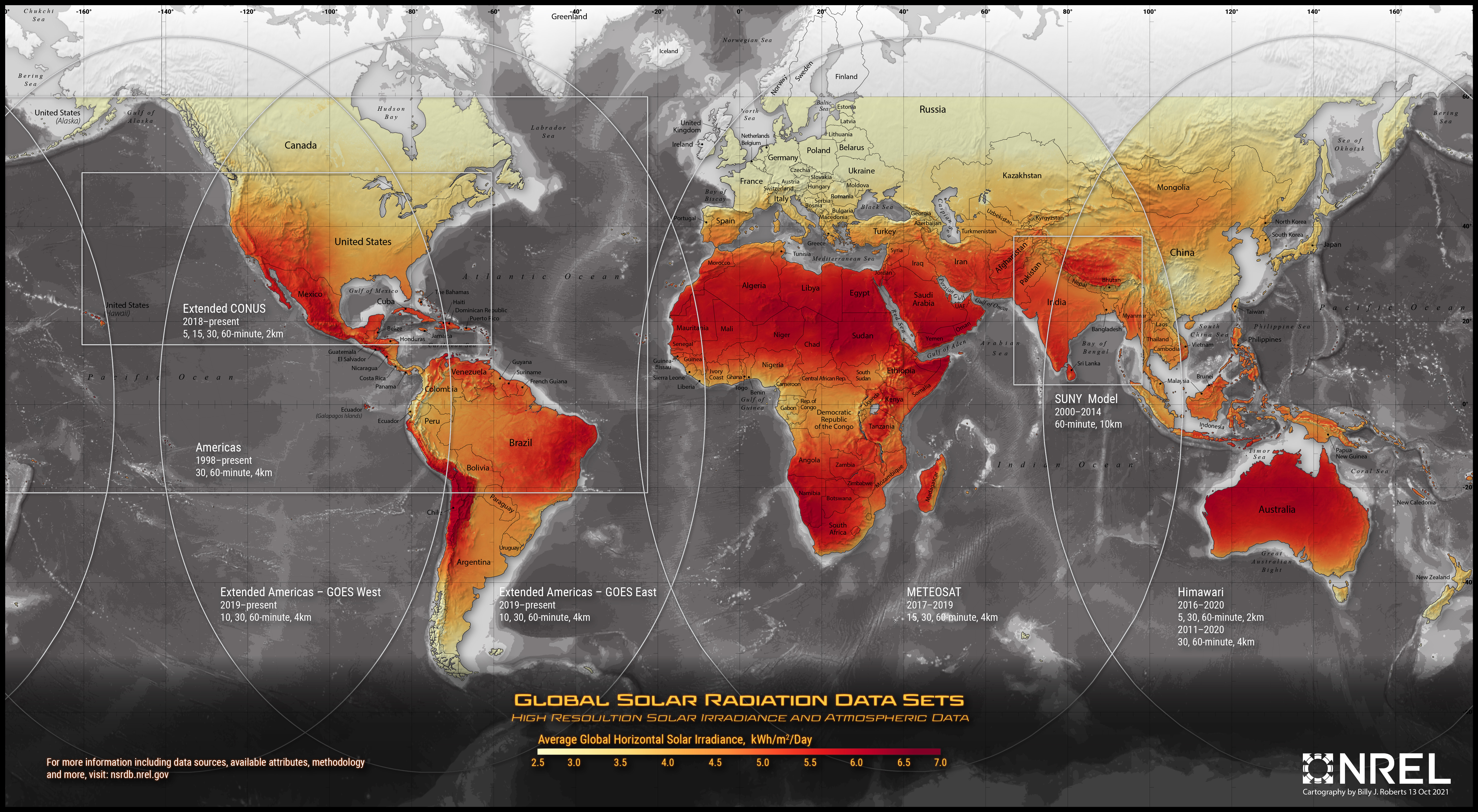
Check out this map of average daily solar irradiance.
https://nsrdb.nrel.gov/assets/NSRDB Graphic Update 2021 09 22.6d4966d2.jpg
As mentioned by other comments, water plays a huge role in absorbing and transporting heat as well as diffusing and reflecting light. As a result, many non equitorial regions are just as sunny as equitorial regions.
Your core premise also has a lot more nuance than you seem to realize. We have seasons because the earth’s tilt moves the maximum solar radiance up and down the tropics. The equator is only the sunniest latitude during the equinoxes. The change in latitude of the sunniest spot (subsolar point) shifts the fastest during the equinoxes since that’s the steepest part of the sine wave. The subsolar point stalls over 23.4 degrees N in June and 23.4 degrees S in Dec. These are the Tropic of Cancer and Tropic of Capricorn https://www.wikipedia.org/wiki/Subsolar_point The increased length of day also exaggerates the effect of the subsolar point drifting. That makes the intensity of summer heat worse than the heat the equator experiences. Any latitude between the tropics actually has two periods of maximum solar intensity per year. If you look at a map of desert biomes, a lot of them are near the tropics.


