

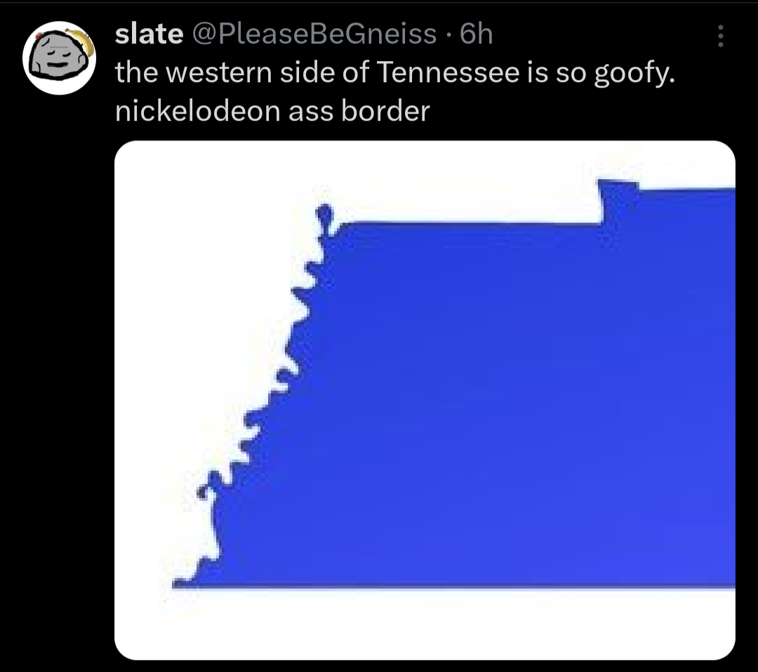
It’s where the Mississippi River was at the time (and still largely is). It’s not like someone just drew it that way.
I believe it’s actually because Tennessee became a state in 1796, but rulers weren’t invented until 1797.
Rulers were invented like 3,000 years before that.
It is a funny picture to think of some Tennessee hillbilly surveyor with a 1ft ruler trying to count out the border though.
Surveyor Steven did his best, but his penchant for TN moonshine was well-documented.
There was a bee chasing him the whole time!
And that’s why they call it a bee-line
Does a river run along that goofy looking border?
Yes. But the border is drawn where the river used to be.
Yup, the Mississippi
Rivers are almost always the culprit of goofy looking boarders
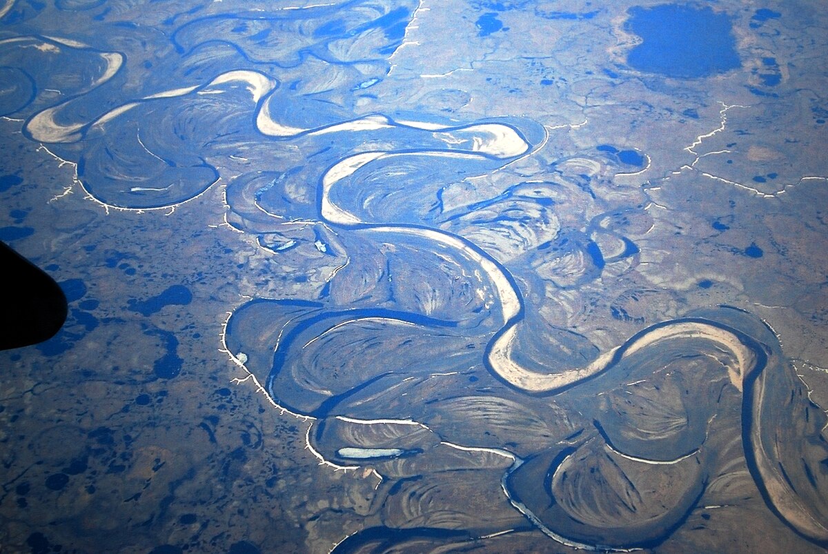
I think most rivers look like that given enough time and erosion. I don’t remember the explanation but I half remember reading that just about any curvy river has carved its riverbed into that shape over very long periods.
water moves faster along the outer bends, giving it an increased capacity for carrying sediments. this results in erosion happening faster near the outer curves. on the other hand, water is slower near the inner bends, forcing the sediments carried by the river to deposit there. this interaction makes the rivers more bendy. an interesting result of this phenomenon is the formation of oxbow lakes (those c-shaped bodies of water separated from the main river)
These videos explain how rivers move and how hard it is to control or predict what they’ll do.
Indeed. Also the little balloon shaped thing in the north west is actually part of Kentucky, but separated from the rest of the state by the river.
Americans seeing borders based on natural features instead of straight lines for the first time:
That’s on western Americans. Over on the East my state’s north and south borders are defined by water features
In Oregon, our northern and eastern borders are mostly defined by rivers. From my perspective, it’d be eastern Americans that don’t get it…
People saying “ya it’s called natural borders yank” as if they don’t come from countries where borders are decided instead by whoever was fucking over whichever disenfranchised minority group at any given time.
Also I actually think borders should be set at watershed boundaries instead of rivers since a lot of cities end up sprawling onto both sides of a river divide. The continental US should have 8 states,
-
Longhouse at the North Eastern watersheds,
-
Sherman along the southeastern, Tennessee Valley, and lower Mississippi watersheds
-
Ohiagan along the Ohio, Great Lakes, Upper Mississippi, and Sourris Red watersheds
-
Texas along the Rio-Grande and Texas Gulf watersheds
-
Buffalo along the Missouri and Arkansas watersheds
-
Sierra along the Colorado and Great Basin watersheds
-
California at the California Watershed
-
Cascadia at the PNW Watershed
Counterpoint: I ain’t sharing a state with missouri
silence Missouri toucher
Rename the Southeast to Sherman? I would like to subscribe to your newsletter.
Ohiagan
🤮🤮
A chance to undo Ohio and he only made it bigger
I mean the only other option that’d even kinda work for the whole region is Tecumseh
Fun fact: watersheds are how we define our regions in NZ.
Though a region may consist of more than one watershed, but not less than one or a partial one.
What happens when the river moves though?
WAR!!!
Nothing, the watershed boundaries are the points where water stops flowing towards one body of water and starts flowing towards another.
I know what a watershed is, we’re talking about borders between states.
Draw a squiggly line that follows the river. You get the left side, I get the right side. The river moves as rivers do. After 100 years we do a survey and find I have a big chunk of property that used to be my side of the river but the river moved towards me and now that’s on your side of the river. I’ve lost some land due to some being on the other side of the river and more due to the land I used to have being a river now.
Is the boundary between us the water and we put up with the uncertain nature of our property, or do we honour the line drawn 100 years ago even though the river isn’t anywhere near there now?
I’m pretty sure rivers don’t run along watershed borders. Which are the borders OP is suggesting.
That squiggly line is the Mississippi river.
While using rivers to divide states may seem conceptually simple, the natural tendency of river courses to change over time has caused complications. If you look carefully at maps and legal history, there are numerous territorial oddities and disputes that have arisen over the years.
For instance, a series of earthquakes in 1811-12 shifted the course of the Mississippi River in a way that stranded two Tennessee towns—Corona and Reverie—west of the river in what seems like it should be Arkansas. Upstream, the same earthquake, and a lack of precision by early surveyors, left a bit of land known as the Kentucky Bend completely surrounded by parts of Missouri and Tennessee. Meanwhile, Kentucky and Indiana have engaged in a protracted debate about which state owned a piece of land near Evansville that connects to Indiana if the river is low but becomes an island if water is high.
You’re the only one talking about rivers in this sub-thread. Not that watershed boundaries can’t change.
Well I see now I commented on the wrong thread.
They change but much more slowly since they change with long term changes in terrain, as opposed to the natural weathering effect of a river, especially one that meanders.
Plus greater watershed boundaries tend to settle around mountain fronts or peaks as well as other such difficult terrains that are less prone to hosting large settlements that could hypothetically get cut off from their own greater metro area, and more likely to already form their own natural barriers just because that happens to be the places where water will begin moving in the other direction towards a different outlet.
You can’t make me do anything with Ohio
-
I invite you to look up the town of Baarle-Hertog/Baarle-Nassau and surrounding area. I would love to describe the area as “on the Dutch/Belgian border”, except there isn’t really much “on” going on there. Seriously, have a look and tell me I’m wrong.
Linked because I haven’t yet learnt to put screen shots in comments.
They place looks like it got bombed in WW1 and the bombing literally broke the borders
Linked because I haven’t yet learnt to put screen shots in comments.
You’ve gotta upload the screenshot to some third-party service. There’s no built-in way to do it.
Then you insert it with

The northern border is only so janky because it follows the Mason-Dickhead line.
How dare you. Jeremiah Dickhead was perfect, and so is his line.
is more suspicious of the “straight” lines supposedly projected into a globe
Goofy?
Angry European noises
That, my friend, is the product of rampant incest.
We’re talking about the BORDER, not the actual state
Edges make cousins.
I live in the slime zone
I live opposite to the slime. My border is nicer, but we live under constant threat of meeting people from the shitty part of Virginia, so it’s not much better.


