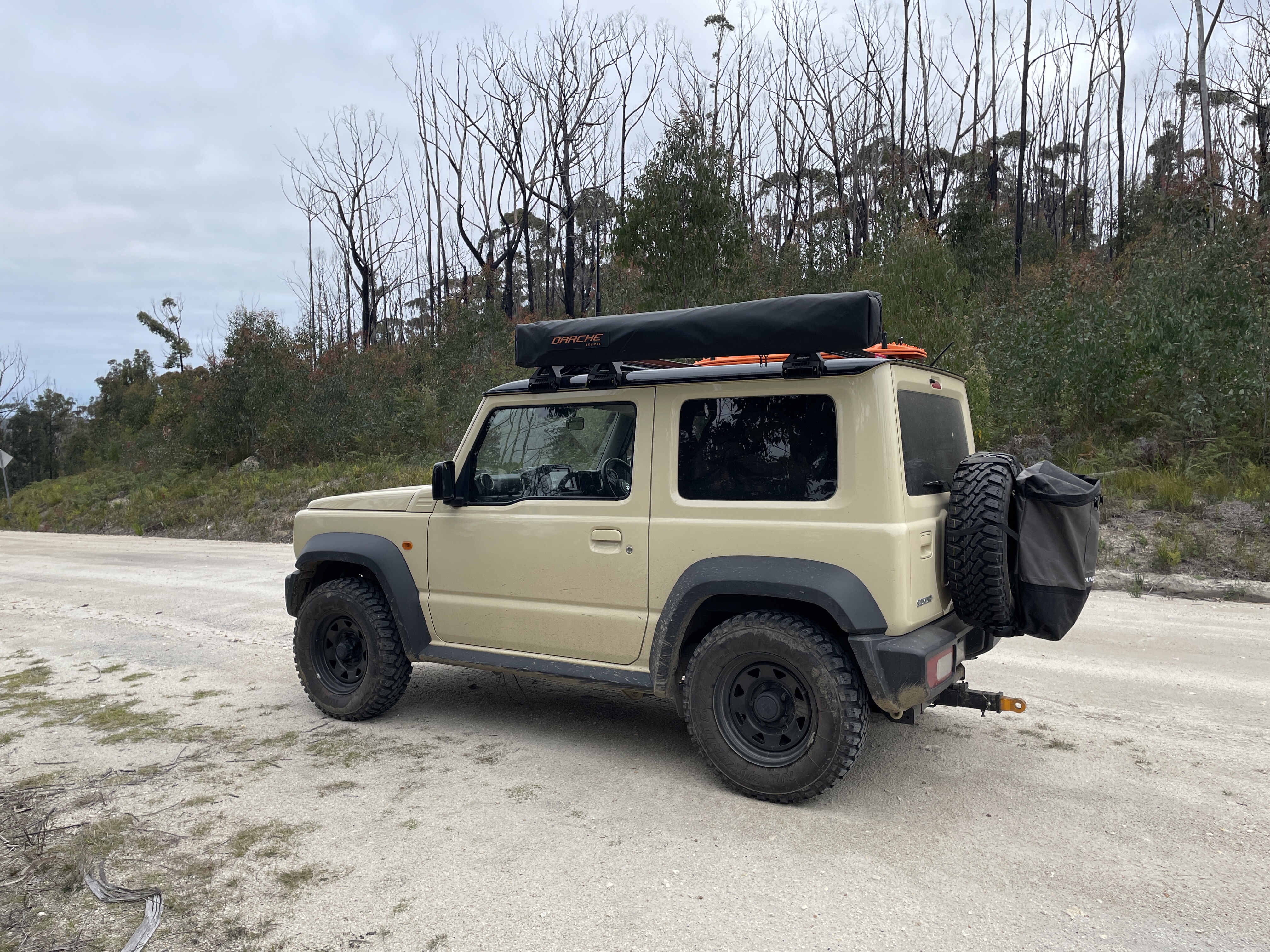
So I’m gonna share a story. In this story I’m a fucking idiot. But I hope that it serves as a warning to someone so they can learn from my dumb mistakes. So I was going out to see some mates the other day in a big state forest near Melbourne.
Decided to take my car (a mid sized AWD SUV) rather than the wife’s small FWD sedan. This proved to be a very good choice. Mind you, my car may be awd but its for like a slightly damp soccer field carpark, not what I accidentally forced it into.
I set google maps on car play and off I go.
Traveling into the park with basically no phone coverage everything going fine till suddenly get told to turn off a decent gravel path onto a side road. No warnings or anything, and again maps said go this way. So I did. It looked OK to start with, but by the time I realized I was was in trouble it was too late.
The road degraded to a goat track and I start sliding down it with no chance of turning around and no phone data to be able to reroute anyway. Maps said I was 10 minutes from meet up point so I decided to push on not really having a choice.
Soon enough i come to a patch of very wet deep tyre tracks. so long as I stick to the high ground I’ll be fine. You can see where this is going, cant you? Yep. She slid straight off the highground into foot deep giant puddles of mud and immediately got bogged.
Chucked the car in mud mode, managed to reverse 2 feet before I couldn’t go any further, put the car back in drive and took off at speed but just got stuck in the same spot again and this time couldn’t reverse.
Now I didn’t panic. That probably saved me. It woulda been easy to accidentally dig her in. My hear beat about 170bpm, but I got out and as calmly as I could assessed the situation. No phone coverage. I walked ahead a bit to make sure I was ok to proceed assuming I could even get out of this mess. I could. Even better there was a downed tree. I grab some branches and stick them under the wheels as best I can. it took about 15-20 minutes. With a dashboard full of warning lights I jump back in and take off slowly, feel it grab some traction in my best Jeremy Clarkson impression scream “SPEED AND POWER” and fucking launch the SUV out of there.
Slowly I proceed to the meet point passing a proper 4x4 who looked at me with shock and horror on his face. A poor little SUV so far out of its depth it wasn’t even funny and an idiot who almost got himself in serious trouble.
I meet at the meeting point and my friends laugh. They approached from another direction and has 0 issues on a smooth gravel road. They all used Google Maps too, it just sent them in a different way for some reason.
So. What did I learn and why am i telling this story? a few key points:
- If your going bush, even on GOOD roads make sure someone knows where you are
- If you start to get into trouble: Reverse. Even if you have to reverse 500m! Dont commit to the fuck up assuming it’ll get better.
- Google maps has no concerns about sending you down tracks that even a dirtbike would struggle with 0 warning.
TLDR: I’ve become one of those “I was just following the GPS” people.
I’m glad you got out of it unscathed. This has been an issue in Australia for a long time (I recall a news article about a farmer who constantly had tourists turning up unannounced on his property because they were blindly following Google or Apple Maps). Without wanting to make you feel too guilty, every time I read one of these stories I’m just astounded that a) people aren’t consulting maps before travelling rurally to get a rough idea of where they need to go and b) that people don’t pull over and do this the moment something seems off.
Maybe it’s because I’m a bit older (not actually old, just not raised by smartphones age) or because I went on many camping trips pre-smartphone as a kid and watched the adults in my family navigate using physical maps (which they also taught me how to read) but I would never in a million years rely solely on GPS navigation if I was driving somewhere for the first time - particularly if it was a rural area. Even in metropolitan areas, I will always do a quick scan of main roads and landmarks first to get a rough imprint of where I need to go so I can focus on driving and only rely on the GPS at the very end.
This isnt a gps specific problem though, its an inaccurate map problem. If the road isnt marked as 4wd only on the paper map you’d be in just as much trouble.
Although i guess the paper map might provide more traction than a gps when you wedge it under the wheel :D
If the road isnt marked as 4wd only on the paper map you’d be in just as much trouble.
That’s not really true. If you are navigating via a physical map and you encounter something unusual, you refer back to the map. At that point you know a) where you are in relation to where you are going and b) that the map has an inaccuracy. Then you make an active decision to either continue on the same route or to find an alternate route. You can still get into trouble, but it will be because you made the choice to risk continuing on your current route instead of taking a different one.
The problem time and time again in these “misled by map app” stories is that the driver never pulls over and looks at the map in detail. They never search for an alternate route or even question whether they are on the best one. They have complete and total faith that their map application knows best and the constant audio prompts reinforce that, so they just keep driving and get themselves into a bad situation without failing any of the skill checks (for lack of a better term) that a physical map user would need to fail to reach the same point.
Nothing you said there is exclusive to paper maps. You can still stop and check the GPS when something is wrong. On a recent holiday I did exactly that when a scenic detour got a lot rougher than expected (It was even better, as i could use the satelite view to see that the road didnt just drive through a lake, which a paper map could not show).
There have been plenty of people who have followed paper maps to their deaths as well. You could argue that GPS has lowered the bar, but its not the map, its the navigator.
I think you sort of missed the point I was making in the second paragraph there. A physical map does not offer real-time navigation or encourage to you continue on your current course in the way that map applications do. Most people who use physical maps do not read the map as they are driving, they read it before they start driving and then refer to it intermittently. As a result, people are more likely to refer to the map if something seems unusual because they might think they’ve misremembered the route and taken a wrong turn. In the same scenario, a navigation app reliant user has fewer barriers to continue on that route because the map is constantly reassuring them that they’re going in the right direction. You say it’s the navigator’s fault, but that’s just the way navigation apps are designed to be used. The entire point of them is that you don’t have to pull over and consult the map because it’s supposed to be constantly updating and correcting itself in real-time. That’s why people are so trusting in them.
I got that, and I do see your point, just disagree with it is all. A physical map can provide very similar levels of encouragement and confidence as a digital one.
As a kid when my parents were teaching me to navigate with melways I made the exact same kinds of mistakes - “The map says its here, it must be here”
Maybe phone apps provide more encouragement, but im unconvinced that “just use a paper map” is actually the answer. Learn your tool is the right answer in my opinion. (And perhaps borrow from Aviation:
AviateDrive, Navigate, Communicate)
This reminds me of a time I got lost - I followed the direction on a road sign to go from a tourist destination I had visited and it pointed me into a plantation where I got lost. Both paper and gps maps were inaccurate and a lot of road were not passable. I pulled over to check the map over and over but the roads didn’t match reality and I kept going in circles and it took me hours to get back out. Not quite as bad as trying to navigate the Epworth Hospital carpark but a close second.
I think you are right. In the end, Turn-By-Turn Navigation is just another driver assistance system that can be turned into a crutch, just like Automatic Transmissions and Automated Cruise Control.
The driver still needs to take responsibility for their driving.
That said, using Turn-By-Turn Navigation is much safer than having the driver flip through the Melways or VicRoads Directory and whilst driving, or flipping and folding a RoofTops map whilst driving.
The problem has always been that Google doesn’t give a shit about user feedback, so it isn’t easy to report an error in Google maps. If you miss a turn, or get bogged down, it should ask for route feedback every time. Either way you should fuck Google and use OpenStreetMaps to evolve a better, non-proprietary, free, alternative.
In 2010 I punched in a waterfall and followed the route. The road was sealed and fine, but Google Maps sent me down the opposite side of a mountain range. When I arrived at the end of the road and it said to continue going straight down a driveway I stopped. Only took a minute for an old mate to show up and tell me that the waterfall was on the opposite side of the mountain and there’s no road to get there before sundown. It’s always done shit like this, and I don’t expect Google to ever care enough to stop shit like this from happening.
Ive had some luck in the past fixing roads in google maps, but havent tried lately. Were paper map publishers better? At least an app can be updated, whereas a published paper map is pretty much static.
A nurse in Canada died because Google maps sent him on a snowmobile/quad trail and his truck was too big for a wood bridge he tried to cross…
https://www.cbc.ca/news/canada/montreal/south-shore-nurse-northern-quebec-cnesst-1.5809425
Wow, that’s definitely one of the more extreme ones I’ve heard. His employer even had a recommended route that he ignored because the Google Maps route was supposedly quicker. Crazy.
yup, maps, real paper maps, read before you leave and take it with you
Death by GPS is a thing.
Great advice. I (used to) only go offroad with a buddy -mostly because my mechanic skills are shit, but also because most of the guys I used to go with bought ALL the toys and mods so they were OVERJOYED when someone like me got stuck and they had to grab thier wench, mud pads, hijack lift, bailing wire, whatever lol.
Also, one time I saw an honest to god Yank Tank (Cadillac?) in the middle of a trail in Colorado where there is no way in hell it should have been.
As an American reading this, “yank tank” is one of the funniest and most spot on things I’ve ever read.
Yeah back when my mates and I had just turned 19 or so we left the territory to go visit some friends in the blue mountains.
I didn’t realise when we set out that I set googlemaps to walking mode because we had been walking around Melbourne a couple days prior when we set off.
Nothing went wrong for a long time, until we were maybe 1km from where we were going up in the blue mountain’s.
Google took is a down a hiking track in the dark in a Nissan xtrail. We only realised the mistake after getting part way through the track and it became so narrow with a drop off on one side that we couldn’t get out the passenger door safely.
I’m glad you’re alright. I remember I was in the car with someone once and we were going to look at Trentham station at night time (odd choice of place to go at night, I know, but it’s a long story). We missed our turn off onto the road the station was on, so rather than getting us to chuck a U turn somewhere, it decided our best option was a 20 min, 4km detour through the state Forest.
Being young and dumb, I figured since we weren’t in a rush, we may as well do it, after all, google maps is usually alright (at least from my perspective as a city dweller). Right after going around a bend it turned from well maintained gravel into a dirt track, and we nearly got bogged. We ended up deciding it was better to find somewhere to turn around, rather than brave another 3km of what was essentially a muddy Mario kart-eque road. We did make it out safely, but it did take a 7 point turn to get out of it
Also, this story from 2012 comes to mind: https://www.cnet.com/tech/mobile/apple-maps-gets-drivers-lost-in-australian-outback-police-warn/. When apple maps first launched, they had Mildura listed as being in the middle of that national park, nowhere near where it actually is:

Thank you. The irony of the situation is I used google maps over Apple cause I was worried about something like this happening.
All maps will have errors.
Even OSM has errors and can sometimes have bad actors and commercial intretests deliberately vandalise content.
If you want to carry a definitive, (relatively) accurate map in Victoria, the VicEmergency App is free and usually has current map data and also has reasonable up-to-date incident conditions. I assume other states have similar services.
“Dont commit to the fuck up assuming it’ll get better.”
Solid advice in adventuring and in life 🤘
Phone coverage is pitiful in most rural areas, and the death of 3G is only going to make it worse.
UHF CB radios are cheap, lightweight and (as long as you don’t use them while driving legal for anyone to (responsibly) use in Australia.
My number one recommendation for safety feature for any vehicle going into regional areas is a UHF. (Second recommendation is rated recovery points, but these are not really applicable unless you plan on off-roading).
Recovery tracks, ropes, winches can be bought in by whoever is coming to rescue you, but without a UHF, you won’t be able to tell them you need rescuing.
I have a couple of cheapo radios, but the range is so poor that i dont really trust them as a viable comms method, especially in mountanous areas.
What radios do you use? I have 2 baofengs BF-F8+++, and a Radtel RT-470.
The baofeng runs at 8Watt, which is higher than the legal power rating in Australia.
https://baofengtech.com/product/bf-f8hp/
The RadTel is even more illegal at 10W.
The power output of the transmitter is not what gets you range, it is the choice of antenna to match the terrain.
They both allow dropping the tramsmit power below 4w, but who knows what they level actually transmit at. If i were using them for anything more than listening to air-traffic control and the occasional road trip i would be a lot more concerned.
My point about the power was that all else being equal, more power is more range. And given the illegal radios way out power yours, but still dont get decent range is a good indication of how bad their antennas are.
Almost every radio reviewer tests line-of-sight range, which is almost always pretty good, so it ends up being meaningless.
My car is a proper 4WD (albeit small) so I have an Australian-made GME XRS-330C installed with an antenna permanently mounted on the roof.
I have an inexpensive GME TX677 in my glove-box for emergencies and an even more inexpensive TX667 in my centre console as a loaner for anyone I am driving with (for their passenger to use, of course).
I plan on upgrading to an XRS-660 as my portable, but it is at the bottom of my Wishlist.
During the chip shortage, I purchased an XRS-330CP as temporary solution. I loan that to family members on touring holidays so we can use the XRS/GPS feature to keep track of each other.
Speaking of which, the GME XRS app has great maps too!
The dedicated car radio + antenna probably helps a lot. The radios i have are many times more powerful than your radios, but when we have tried to use them hiking, they just dont cut it. They are also half the price of your inexpensive radio, so you get what you pay for :D
Yeah, we have some of the no-name UHF radios in the kids toybox.
We don’t put batteries in them, in case the kids hear something on the airwaves that isn’t suitable for young children.
We have one high-end Chinese UHF in the garage in a box. It was purchased because it could be reprogrammed to pickup all 80 UHF channels instead of just the 40 that were available for public use. It has never been used.
Google maps took me to the ordnance training entrance to Puckapunyal. A 10ft wire fence in the bush with a bunch of signs stating that past this point is a live atrillery training ground or something like that. Many warning of how likely you are to die if you continue.
Once, google maps wanted me to cross a freeway on foot to get to a job interview. Fuck google maps.
You saw something you considered a “goat path” and continued…